Diese Übersetzung ist älter als das Original und ist eventuell veraltet. Änderungen zeigen.
Übersetzungen dieser Seite?:
Dies ist eine alte Version des Dokuments!
 Diese Seite wurde noch nicht vollständig übersetzt. Bitte helfen Sie bei der Übersetzung.
(diesen Absatz entfernen, wenn die Übersetzung abgeschlossen wurde)
Der Kompass ist eine in c:geo eingebaute Navigationsmethode in c:geo. Du kannst den Kompass von der Cachedetail-Seite sowohl für den Cache selber aber auch für jeden Wegpunkt eines Caches.

Der obere Bereich des Kompass enthält weitere Funktionen, die entweder als Symbol in der Titelzeile oder im sogenannten Überlaufmenü. Alle verfügbaren Funktionen werden im Folgenden erklärt.
Die Symbole in der Titelzeile und der Inhalt hinter dem Überlauf-Symbol werden dynamisch basierend auf deiner Geräteauflösung und Bildschirmausrichtung verteilt. Daher ist es möglich, dass auf deinem Gerät mehr oder weniger Einträge entweder als Symbol angezeigt oder hinter dem Menü-Symbol versteckt sind.
Wenn ein Menüeintrag als Symbol angezeigt wird, kannst du lange auf das Symbol klicken um seine Funktion angezeigt zu bekommen.
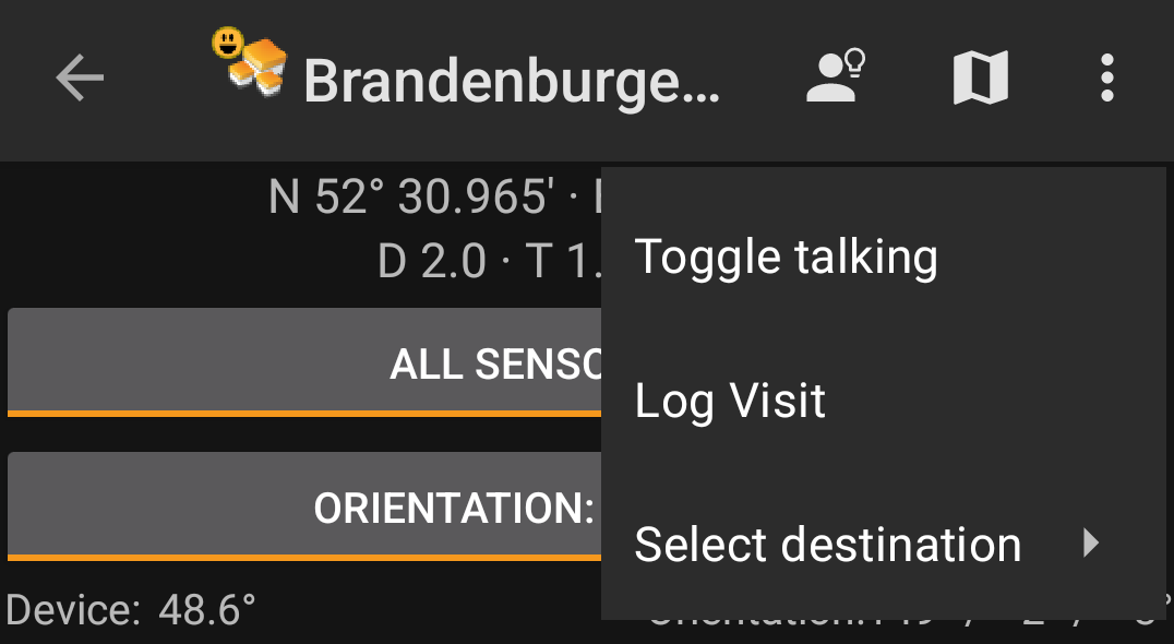
| Symbol | Funktion | Beschreibung |
|---|---|---|
 | Hinweis | Dies zeigt ein kleines Pop-up-Fenater über dem Kompass, die den Cachehinweis anzeigt (wenn der Besitzer des Caches einen solchen angegeben hat). |
| Zeige auf Karte | Öffnet die Zielkoordinaten auf derKarte. | |
| Überlauf-Menü | Ein Klick öffnet das Menü der Funktionen, die nicht mehr als Symbol in die Titelzeile auf deinem Gerät passen und daher als Liste angezeigt werden. Die Funktionen in dieser Liste werden auch alle in dieser Tabelle beschrieben. | |
| Starte Sprache | Startet eine Text-nach-Sprache Ausgabe der Richtung und Entfernung zum Ziel. Du kannst die Anzeige deines Telefons ausschalten, sobald die Sprachausgabe gestartet wurde. |
|
| Besuch loggen | Öffnet die Logseite für den Cache. | |
| Ziel wählen | Erlaubt es das Kompassziel zwischen den verfügbaren Wegpunkten des Caches zu wechseln. |
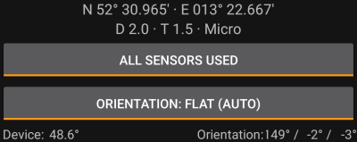
The top section of the compass screen shows the target coordinates and the D/T-rating and size information of the cache.
The button shown below can be clicked to toggle between GPS and Magnetic compass used and GPS only used. Disabling of the magnetic compass will instead use the change of the GPS position to estimate the direction of your movement. This feature is not as precise as the magnetic compass but can be useful if you e.g. use the talking compass and want to store your phone in your pocket (no longer pointing into the walking direction).
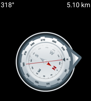
The top line will show the bearing towards north and the distance to your target coordinates. The distance might be shown in miles(mi) or kilometer(km) depending on your settings.
The compass rose will show you the hemisphere orientation in its inner circle and the direction to the target with the combination of a red line and an outer arrow pointing to the target.
The compass rose will rotate corresponding to the direction of your device, thus always pointing towards your navigation target.
The bottom section of the compass screen shows your current coordinates and some status information about the current GPS signal quality and accuracy. Refer to the main screen status description for further details.
