Diese Übersetzung ist älter als das Original und ist eventuell veraltet. Änderungen zeigen.
Übersetzungen dieser Seite?:
Dies ist eine alte Version des Dokuments!
Wenn deine persönliche Notiz zu einem Cache gültige Koordinaten (z.B. N50 10.123 E010 34.876) enthält, erstellt c:geo im Wegpunkt-Reiter dieses Caches automatisch einen Wegpunkt daraus.
Wenn deine persönliche Notiz zum Beispiel folgendermaßen aussieht:
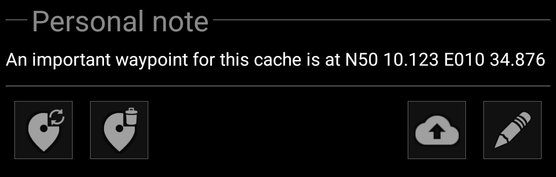
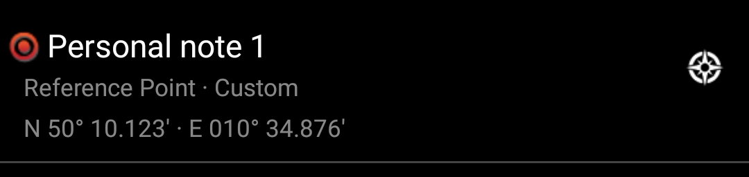
erstellt c:geo automatisch den folgenden Wegpunkte dafür:
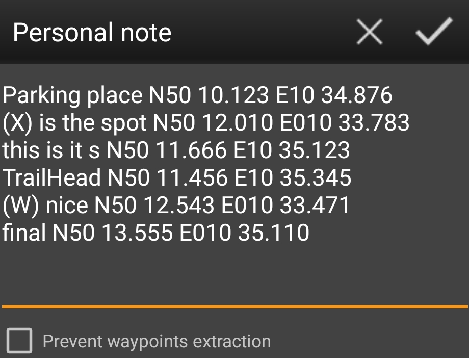
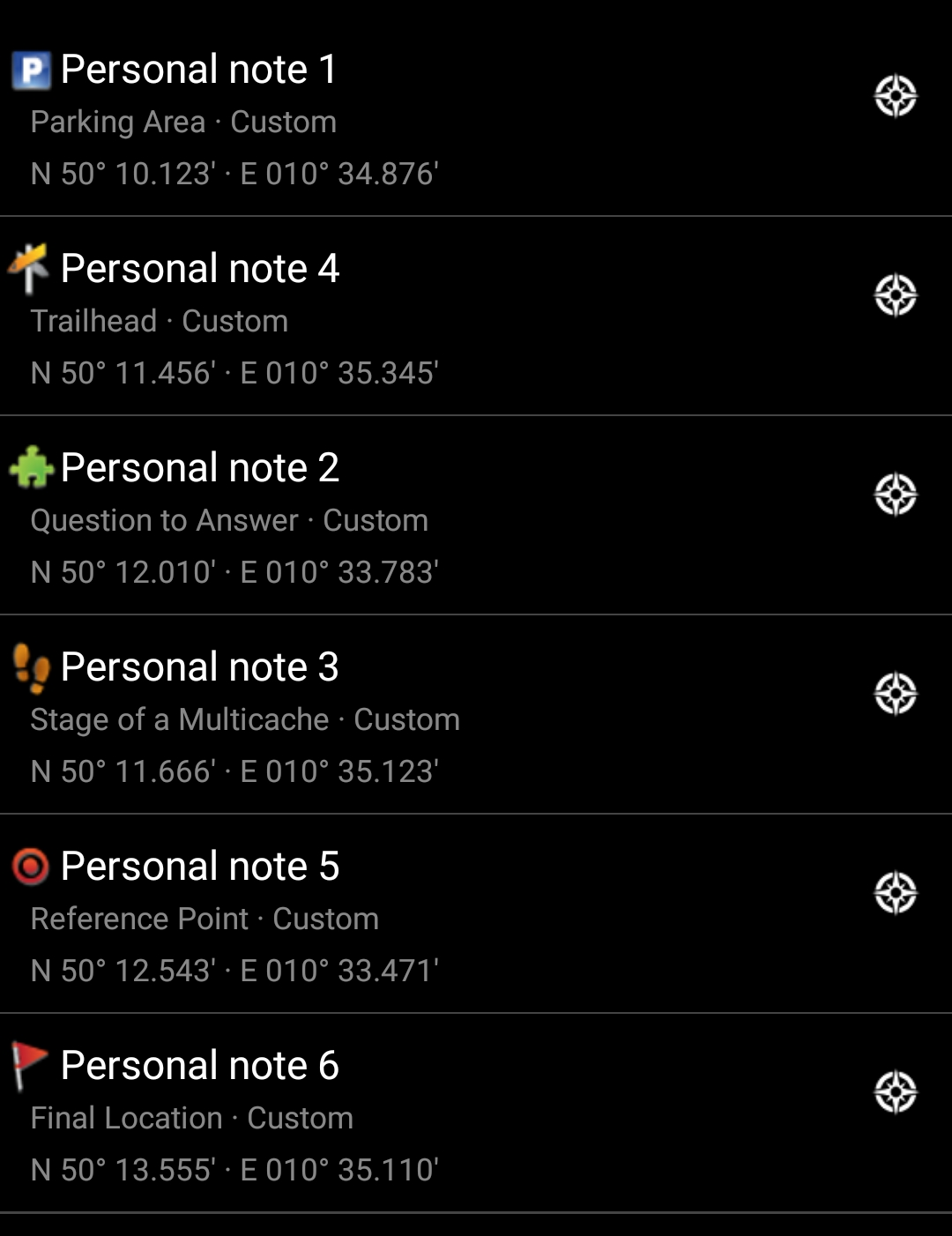
Weitere Koordinaten in deiner persönlichen Notiz werden gleichermaßen in Wegpunkte übertragen und der Wegpunktname wird entsprechend nummeriert.
Wenn die Wegpunkte eines Caches bereits die gleichen Koordinaten enthalten, wie sie in deiner persönlichen Notiz gefunden wurde, erstellt c:geo nicht automatisch einen neuen Wegpunkt für diese Koordinaten, da angenommen wird, dass es in diesem Fall eine unnötige Verdoppelung wäre. Zwei Koordinaten werden als „gleich“ in diesem Sinne betrachtet, wenn sie im MinDec-Koordinatenformat (z.B. N50 10.123 E010 34.876) vorliegen und identisch sind.
Normalerweise definiert c:geo den Typ des Wegpunktes für Koordinaten, die in der persönlichen Notiz gefunden wurden, als Referenzpunkt. Du kannst allerdings Schlüsselwörter in deiner persönlichen Notiz verwenden, um andere Wegpunkttypen zu definieren.
Platziere dazu einfach eines der folgenden Schlüsselwörter vor die Koordinaten:
| Symbol | Wegpunkt-Typ | Schlüsselwort in persönlicher Notiz | Kurz-ID in persönlicher Notiz |
|---|---|---|---|
| Parkplatz | PARKING | P | |
| Station mit Frage | PUZZLE | X | |
| Station eines Multi-Caches | STAGE | S | |
| Ausgangspunkt | TRAILHEAD | T | |
| Referenzpunkt | WAYPOINT | W | |
| Final | FINAL | F |
c:geo erkennt die folgenden Schlüsselwort-Formate als Erkennung für den Wegpunkt-Typ (alle unabhängig von Groß-/Kleinschreibung:
(f) für einen Final-Wegpunkt)Zusätzlich funktionieren auch übersetzte Wegpunktnamen (in der Sprache, in der du c:geo verwendest), aber da c:geo in vielen verschiedenen Sprachen verfügbar ist, beschränken wir uns in dieser liste auf die englischen Schlüsselwörter.
Als Beispiel schau dir die folgende persönliche Notiz an, die einige der oben beschriebenen Varianten zur Erstellung verschiedener Wegpunkt-Typen nutzt:
Dies erstellt dann automatisch diese Wegpunkt für dich:
 ÜBERSETZUNG!!
Perhaps you noticed that waypoints from personal note were created with default names like e.g. Personal Note 2. If you want to perform more advanced waypoint operations from your personal notes you have to use advanced waypoint syntax. With this you can:
To do this, use the following syntax in your personal note:
@[<prefix>]<name> (<waypointTypeId>) <coordinate> „<user note>“
Advanced format is recognized when it starts with a @ at the beginning of a new line. The following content is parsed:
@ and the coordinate is considered to be a part of the waypoint name, except when it is in parenthesis ()@ is directly followed by square brackets [], then the content of these brackets is considered to be the prefix of the waypoint you want to edit„ (in same or next line), then everything between this “ and the next „ is considered to be part of the waypoint's user note (including line breaks). If the coordinate is not followed by “ but has additional content on same line, then this content is considered to be the waypoint's user note(NO-COORD) which can be used to specify an empty coordinate (this is necessary in the very special case that one wants to modify the user note of a predefined waypoint which has no coordinate)The geocaches waypoint list is modified with this information as follows:
In case a waypoint is modified, the following rules apply:
The following examples show different texts on the left and the waypoints created out of them on the right
| Personal note text | produced waypoint |
|---|---|
@ A good parking place N50 11.456 E010 35.345 park under the oak tree |  |
@ (X) marks the spot N50 12.010 E010 33.783 |  |
@[S5]Station 5 (X) (NO-COORD) „We have to think about this later“ (Note: this example assumes that there is a predefined waypoint in the listing with prefix S5) |  |
