Deze vertaling is ouder dan de originele pagina en kan verouderd zijn. Kijk wat er is veranderd.
Vertaling van deze pagina?:
Dit is een oude revisie van het document!
 Deze pagina is nog niet volledig vertaald. Help alsjeblieft de vertaling compleet te maken.
(verwijder deze paragraaf als de vertaling is voltooid)
Terwijl het kaartscherm wordt weergegeven, wordt je mobiele apparaat voor het gemak niet automatisch uitgeschakeld. Je moet dit scherm verlaten om terug te keren naar de automatische (getimede) uitschakeling voor energiebesparing. Natuurlijk werkt het handmatig in- en uitschakelen van uw mobiele apparaat nog steeds zoals gewoonlijk.
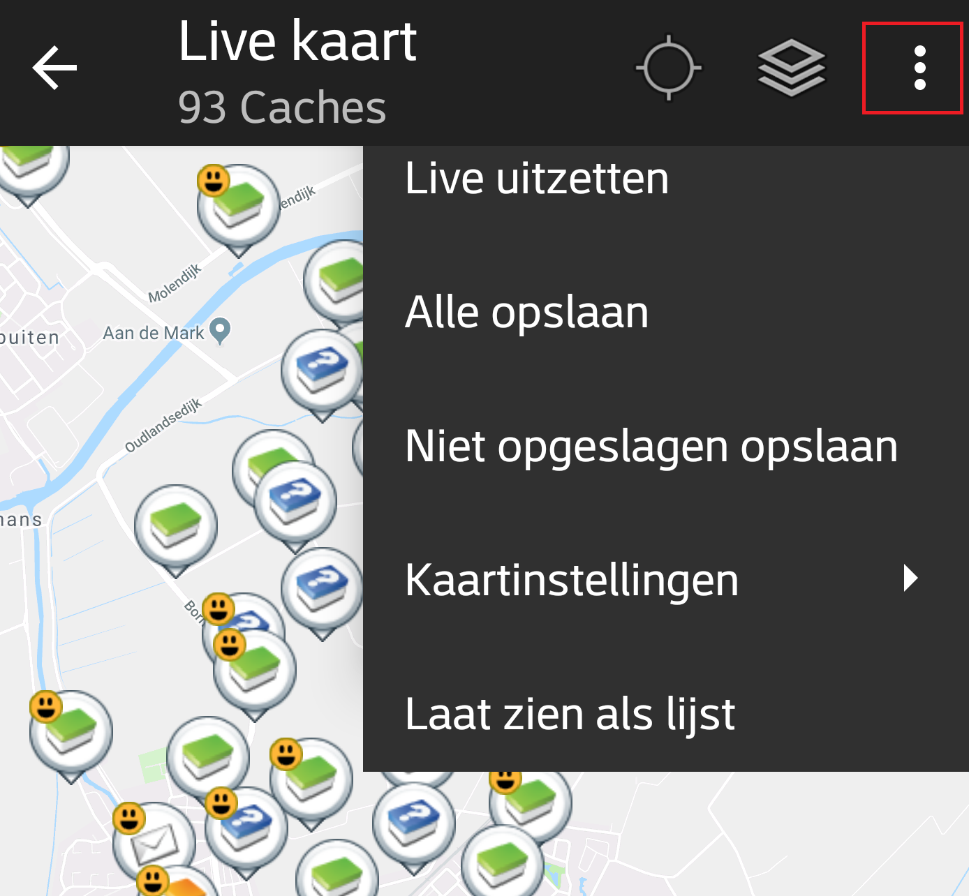
De pictogrammen in de bovenste balk en de inhoud achter de knop worden dynamisch getoond op basis van de apparaatresolutie en de schermoriëntatie. Het is dus mogelijk dat er meer of minder items achter de menuknop worden weergegeven of als pictogrammen in de bovenste balk van uw apparaat worden getoond.
Als een menu-item wordt weergegeven als pictogram, kun je langere tijd op het pictogram drukken om een pop-up te krijgen met de functie ervan.
| Icoon | Functie | Omschrijving |
|---|---|---|
 | Kaart info | Toont de status van de huidige kaart: Live kaart in het geval de kaart live is, Kaart als de live modus uitgeschakeld is of de naam van een lijst.Daarnaast wordt het aantal caches weergegeven, die op de kaart worden getoond. |
| Voortgang indicator | Er wordt een draaiende voortgang indicator getoond wanneer de live kaart aan het laden is van de geocaching servers en/of van je cachelijst. Het zal verdwijnen als de live kaart klaar is met laden. | |
| Centreer Positie | Deze knop kan worden gebruikt om de kaart te centreren op je huidige positie. Als de kaart is gecentreerd op jouw positie zal het icoon gevuld zijn. |
|
| Kaartbron selectie | Gebruik deze knop om de actieve kaartbron te wijzigen. | |
| Overflow Menu Knop | Door deze knop aan te raken worden alle overige functies getoond, die niet op de bovenste balk van je apparaat passen en zullen als daarvoor in de plaats als een lijst worden getoond. De functie s die in de lijst worden getoond worden ook in deze tabel worden beschreven. | |
| Live aan- / uitzetten | Deze functie schakelt het automatisch updaten van de live kaart aan of uit. | |
| Alle opslaan | Slaat alle caches op als lijst, die momenteel worden getoond op de kaart. De caches die al opgeslagen zijn zullen tijdens dit proces worden ververst. | |
| Niet opgeslagen opslaand | Slaat alle caches, die worden getoond op de kaart op, behalve degenen die reeds zijn opgeslagen in een lijst. | |
| Kaartinstellingen | Dit zal een menu openen met verschillende opties om de kaart aan te passen (bijv. caches verbergen, cirkels laten zien). | |
| Routing | Deze functie maakt het mogelijk om te switchen tussen routing voorkeuren (bijv. rechte lijn, auto route, fiets route). | |
| Laat zien als lijst | Dit zal de caches die op de kaart worden getoond presenteren als cache lijst. | |
| Spoor geschiedenis wissen | Dit zal de geschiedenis wissen van de sporen op de kaart. |
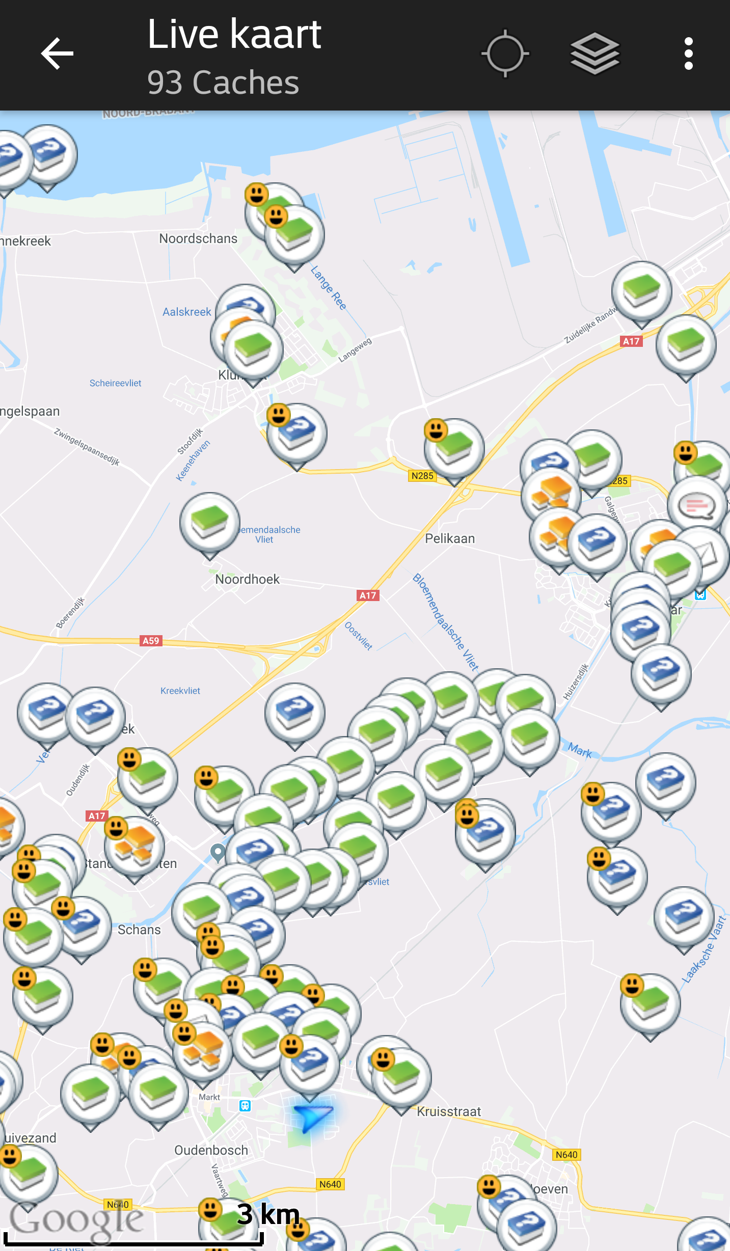
De kaart zal je het geselecteerde kaart type tonen met een live weergave van alle beschikbare caches op de getoonde locatie.
De live kaart toont altijd een combinatie van caches van de door jou ingestelde geocaching platformen alsmede opgeslagen caches in jouw cache lijsten als niet opgeslagen caches.
De volgende tabel brschrijft de verschillende markeringstypen die gebruikt worden op de live kaart.
De tabel zal alleen de verschillende icoontjes beschrijven, niet de verschillende typen geocaches. Druk op de volgende link voor meer informatie over de Geocache Iconen en Geocache markering iconen in c:geo, welke door heel c:geo worden gebruikt.
| Icoon | Omschrijving |
|---|---|
| Deze pijl toont jouw huidige positie en oriëntatie op de kaart. | |
| Positie van een cache van geocaching.com. De pijl wijst naar de coördinaten van de cache op de kaart. Het frame van het icoontje zal het corresponderende cache type bevatten. | |
| Positie van een uitgeschakelde of gearchiveerde cache van geocaching.com. De pijl wijst naar de coördinaten van de cache op de kaart. Het frame van het icoontje zal het corresponderende cache type bevatten. | |
| Positie van een cache van opencaching platform. De pijl wijst naar de coördinaten van de cache op de kaart. Het frame van het icoontje zal het corresponderende cache type bevatten. | |
| Positie van een uitgeschakelde of gearchiveerde cache van opencaching platform. De pijl wijst naar de coördinaten van de cache op de kaart. Het frame van het icoontje zal het corresponderende cache type bevatten. | |
| Positie van een cache van een ander platform dan geocaching.com of opencaching (bijv. extremcaching.com). De pijl wijst naar de coördinaten van de cache op de kaart. Het frame van het icoontje zal het corresponderende cache type bevatten. |
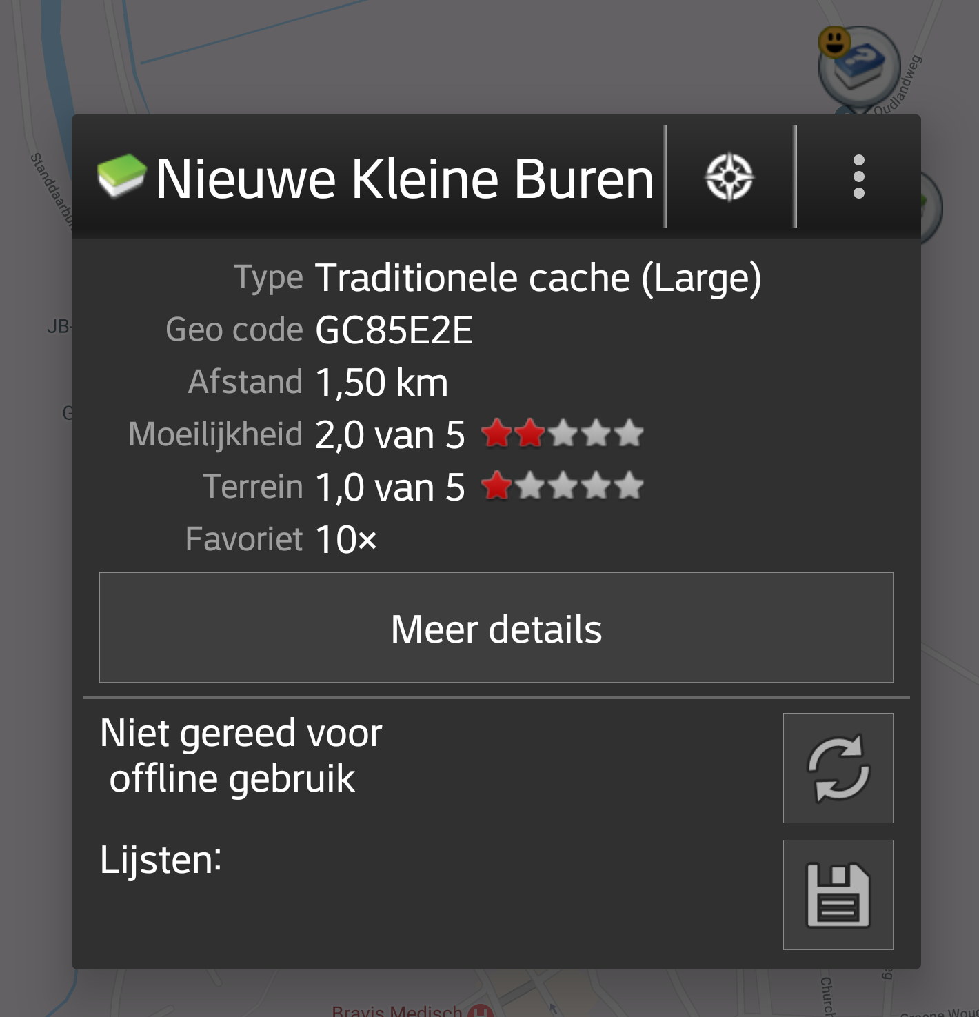
Als je op een cache drukt op de live kaart zal er een popup scherm verschijnen boven de map met informatie over de geselecteerde cache:
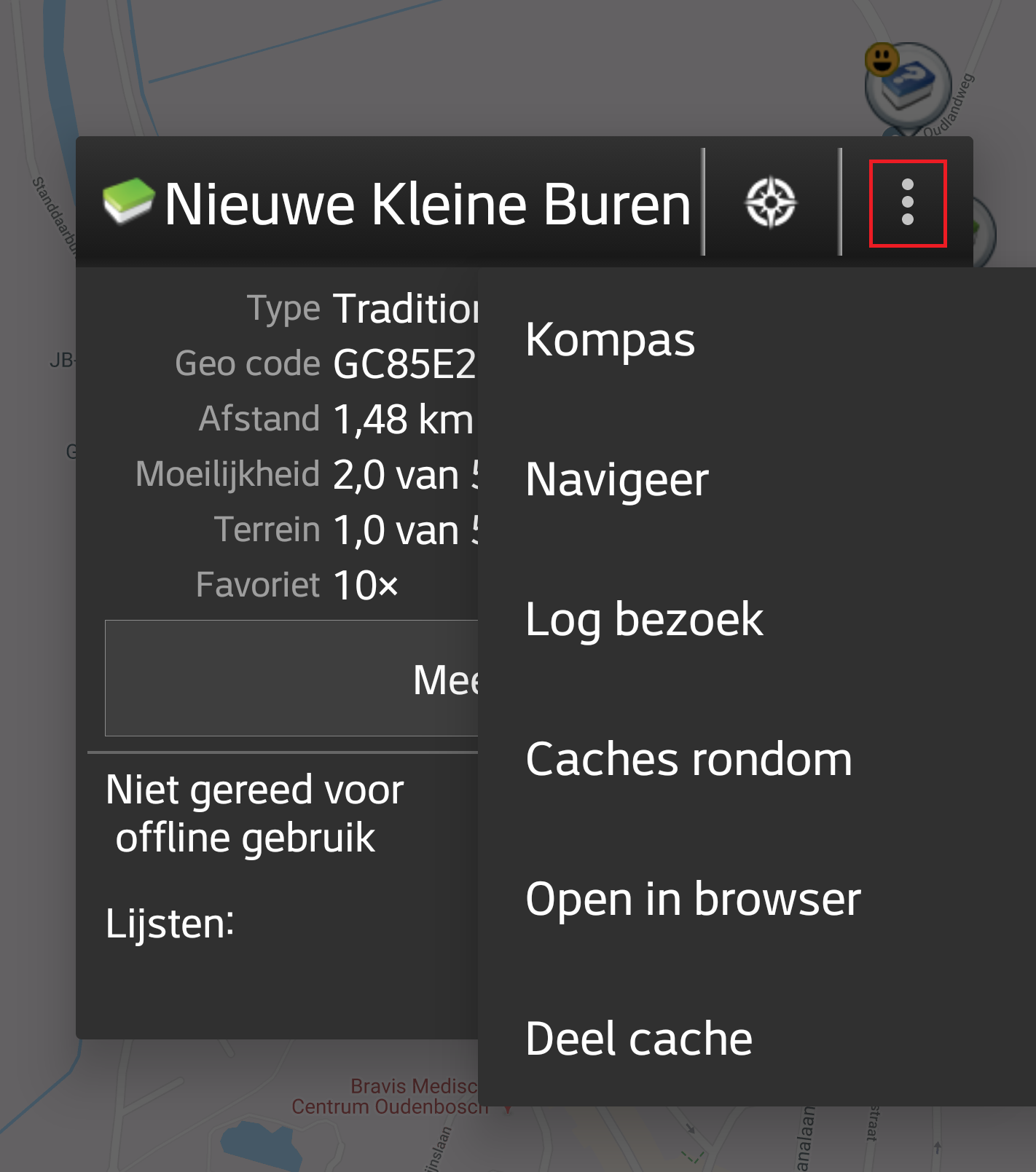
Deze sectie van de kaart toont verschillende menu opties voor de geselecteerde cache.
| Icoon/Optie | Omschrijving |
|---|---|
 | Toont het cache type icoon en de titel van de geslecteerde cache. |
| Een korte druk op dit icoontje zal je standaard navigatie hulpmiddel opstarten om te kunnen navigeren naar de geselecteerde cache. Bij het lang indrukken van dit icoontje zal je secondaire navigatie hulpmiddel worden geactiveerd. |
|
Deze optie schakelt de lijn van de richting / routering tussen jou en de geselecteerde cache aan of uit. Deze optie is momenteel alleen beschikbaar op de OSM online kaart en de offline kaarten. Deze optie is momenteel alleen beschikbaar op de OSM online kaart en de offline kaarten. |
|
| Deze optie opent een menu met extra opties, zoals in deze tabel verder wordt beschreven. | |
| Kompas | Dit opent het kompas voor deze cache. |
| Navigeer | Dit opent een lijst met alle beschikbare navigatie hulpmiddelen die je kunt gebruiken voor deze cache. |
| Log Visit | This opens the logging window to log the selected cache. |
| Caches around | This option starts a nearby search around the coordinates of the selected cache and will display the results. |
| Open in browser | This option opens the cache listing on the geocaching web page using your internet browser. |
| Remove | This option will delete the cache from your stored lists. GITHUB → KANN WEG |
| Share Cache | Will share a link to the cache using the built-in Android share options. |
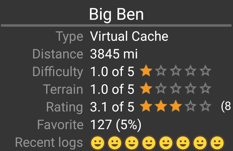
The middle section of the map popup window shows helpful information about the selected cache. Some of the information might not be shown depending on the loading status of the selected cache (e.g. due to the [livemap#strategy| loading strategy]].
| Heading | Description |
|---|---|
| Type | Type of the selected cache. |
| Geo code | Geo code of the selected cache. |
| Distance | Distance to the coordinates of the selected cache from your current position. |
| Difficulty | Difficulty rating of the selected cache shown as decimal value as well as graphical. |
| Terrain | Terrain rating of the selected cache shown as decimal value as well as graphical. |
| Rating | Shows the quality rating of this cache from GCVote if this service is enabled in the c:geo settings as decimal value as well as graphical. The value shown in parenthesis is the number of votes given for this cache. |
| Favorite | The amount of favorite points (geocaching.com) or recommendations (Opencaching platforms) the selected cache has been awarded. |
| More details | This button will take you to the cache detail page of the selected cache providing the full information for this geocache. |
| This button is only available if the cache as a owners hint or a personal note stored. Clicking the button will display the hint and/or personal note at the bottom of the popup window. |
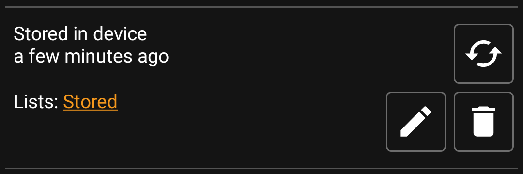
This section of the map popup provides several options to manage the storage state of the selected cache.
| Icon/Option | Description |
|---|---|
 | This field provides information if the selected cache is stored on your cache lists and for how long the cache is stored (i.e. gives you an indication of how up-to-date the shown details are). |
| Clicking this button will refresh the cache information by updating it from the geocaching server. | |
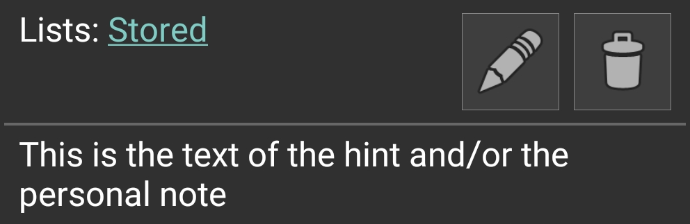
 | In case the selected cache is already stored in your cache lists this field shows you the list(s) it is stored in. |
| This button is only shown if the selected cache is not yet stored in your cache lists and will store it. A long press on this icon will store the cache to the last used list, instead of asking for the list. |
|
| If the selected cache is already stored in your cache lists this icon is shown and allows you to modify the list or add the cache to another list. | |
| If the selected cache is already stored in your cache lists this icon is shown and allows you to delete the cache from your lists. |
If you clicked the hint button in the cache information section of the popup window, the owners hint and/or your personal note will be shown at the bottom of the popup window. In case of a long text you can scroll this part of the popup window.
After selecting the menu function Map settings the following option screen will be shown:

| Option | Description |
|---|---|
| Hide own/found caches | If activated your owned and found caches are hidden on the map. This is the same option as also available in c:geo settings and changing it here will change it also permanently in your settings. Please note, that some technical limitation apply for hiding your owned and found caches as explained on the settings page |
| Hide disabled caches | If activated disabled caches are hidden on the map. This is the same option as also available in c:geo settings and changing it here will change it also permanently in your settings. Please note, that some technical limitation apply for hiding hidden caches as explained on the settings page |
| Show direction | This will enable/disable the direction line/routing shown between your position and a selected cache. |
| Show circles | If activated c:geo will show circles with a distance of 1/10 mile (161 meters) around all physical waypoints (i.e. traditional caches, physical stages of a cache, mystery caches with corrected coordinates). This is the minimum distance placed caches need to have on geocaching.com and these circle might be helpful when you are planning to hide a new cache and are looking for a position. |
| Show trail | With this option you can activate a trail showing your position history (your movement) on the map. This is the same option as also available in c:geo settings and changing it here will change it also permanently in your settings. |
| Use compact icons | This option will switch from the classic cache icon view to a compact view showing single caches as a colored dot only. The colors represent the cache type according to the color of the classic icon (e.g. Traditional caches are shown as green dot). |
After selecting the menu function Routing the following option screen will be shown:
This setting is will only be shown if a supported routing app is installed and available.
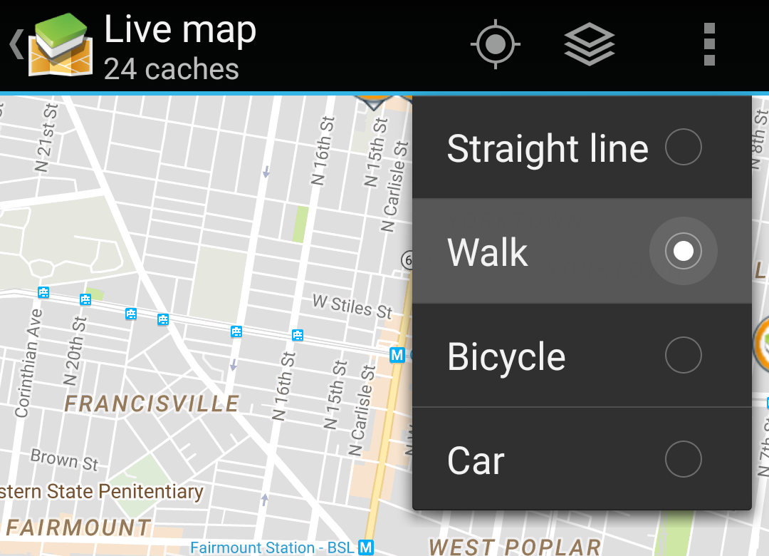
| Option | Description |
|---|---|
| Straight line | This will show a direct line (air distance) between your position and the selected cache. |
| Walk | This will set the routing app to draw a line following turn-by-turn navigation for pedestrians. |
| Bicycle | This will set the routing app to draw a line following turn-by-turn navigation for bikers. |
| Car | This will set the routing app to draw a line following turn-by-turn navigation for cars. |
