Sidebar
Table of Contents
c:geo Settings

The following pages describe the functions of the setting menu in c:geo.
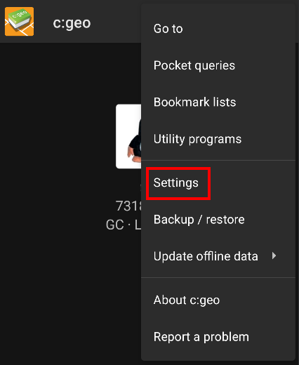
You can access the settings by tapping on the menu button (three dot button) in the upper right of the main menu and selecting Settings:
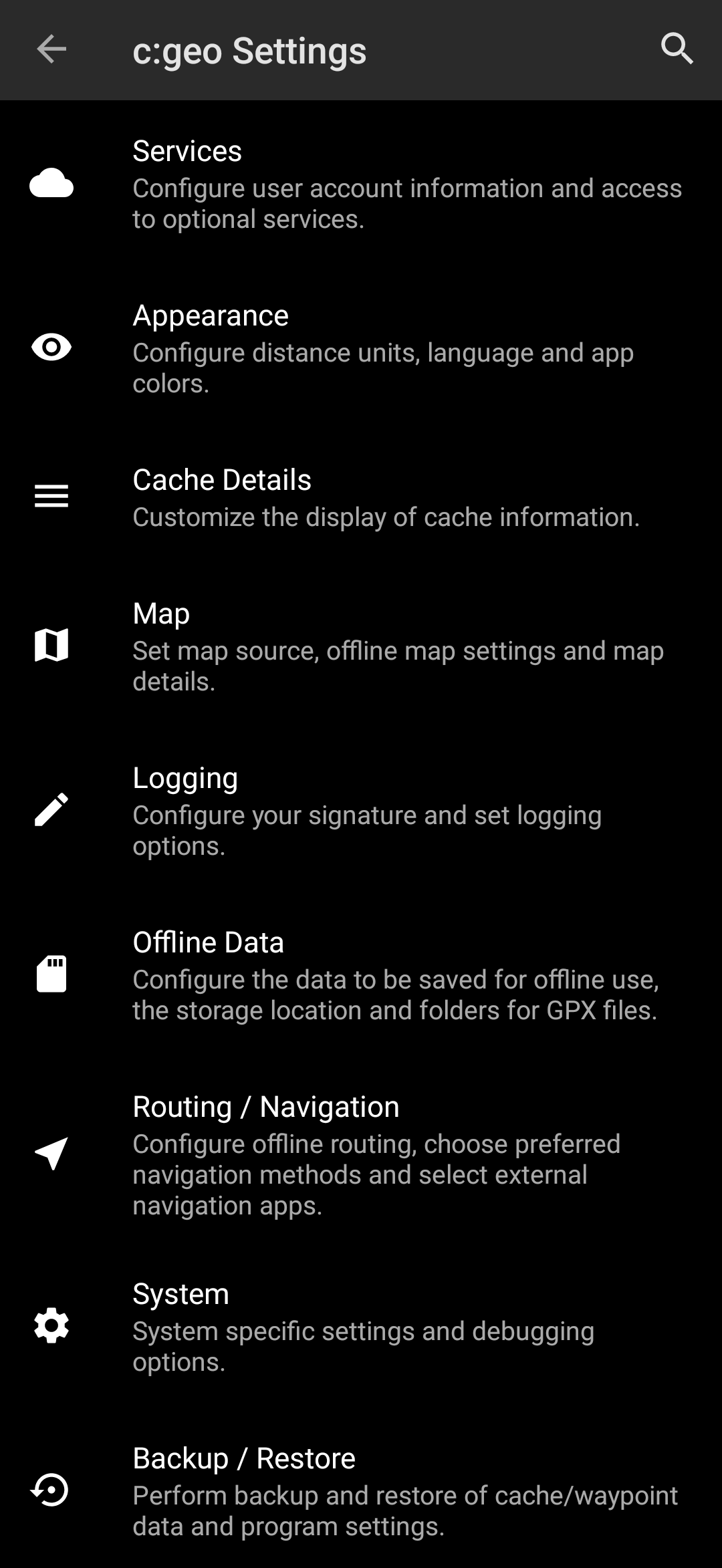
In this menu you will find the following categories of settings which will be described below in detail:
| Icon | Menu item | Content |
|---|---|---|
 | Services | Configure geocaching services you would like to use, modify your user account information and access additional services such as GCVote, send2cgeo |
 | Appearance | Configure distance units, language and app colors |
 | Cache Details | Customize the display of cache information and hide out certain caches |
 | Map | Configure map sources, folders for offline maps and set up offline maps and map details |
 | Logging | Customize logging options and create or modify your logging signature |
 | Offline Data | Configure the data to be saved for offline use, the storage location and directories for GPX files. |
| Routing / Navigation | Configure offline routing, chose preferred navigation methods and select external navigation apps | |
 | System | Configure app directories and other system specific settings |
 | Backup & Restore | Perform backup and restore of cache/waypoint data and program settings |
Services
Geocaching
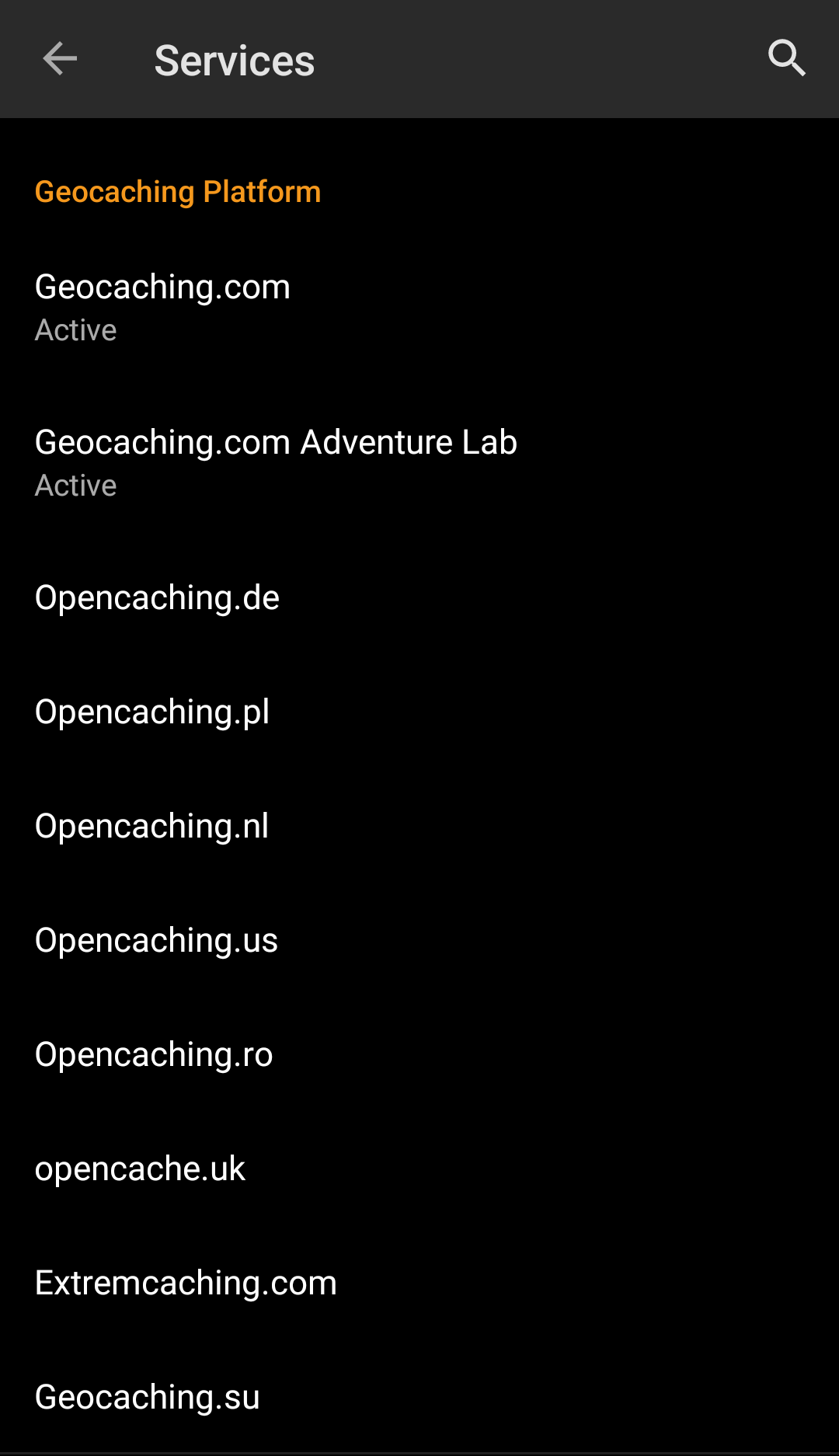
In the first section of the service settings you can configure the connection to the different supported geocaching platforms. Currently c:geo supports the following geocaching services:
| Service | Description |
|---|---|
| geocaching.com | The currently largest commercial Geocaching platform with caches hidden worldwide |
| Opencaching Germany | Open-Source and free to use Geocaching platform for Geocaches in the whole world with focus on Germany, Austria, Switzerland, Italy and Spain |
| Opencaching Poland | Open-Source and free to use Geocaching platform for Geocaches in Poland |
| Opencaching Netherlands | Open-Source and free to use Geocaching platform for Geocaches in the Netherlands |
| Opencaching USA | Open-Source and free to use Geocaching platform for Geocaches in the United States of America |
| Opencaching Romania | Open-Source and free to use Geocaching platform for Geocaches in Romania |
| Opencaching UK | Open-Source and free to use Geocaching platform for Geocaches in the United Kingdom |
| extremcaching.com | Privately operated geocaching platform with focus on Geocaches with a high terrain rating in German speaking regions |
| Geocaching Russia | Privately operated geocaching platform for Geocaches in Russia |
A detailed description of the authentication procedure for these geocaching services can be found in the First Steps with c:geo.
Furthermore you can use the service menu to configure the connection to the following additional services, which are available in c:geo afterwards:
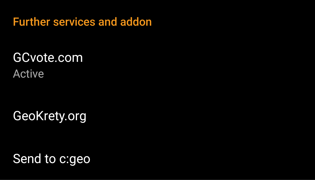
| Service | Description |
|---|---|
| GCVote | A platform for voting on the quality of Geocaches |
| GeoKrety | An alternative platform for Trackables |
| Send2cgeo | Offers a browser script to directly import Geocaches to c:geo by single click on the geocaching website on your PC. Take a look at the website of send2cgeo to learn more about this tool. |
Social media

You can authorize c:geo to post on Twitter each time you send a log for a cache or trackable. After tapping on the Twitter button the authorization screen will be shown:
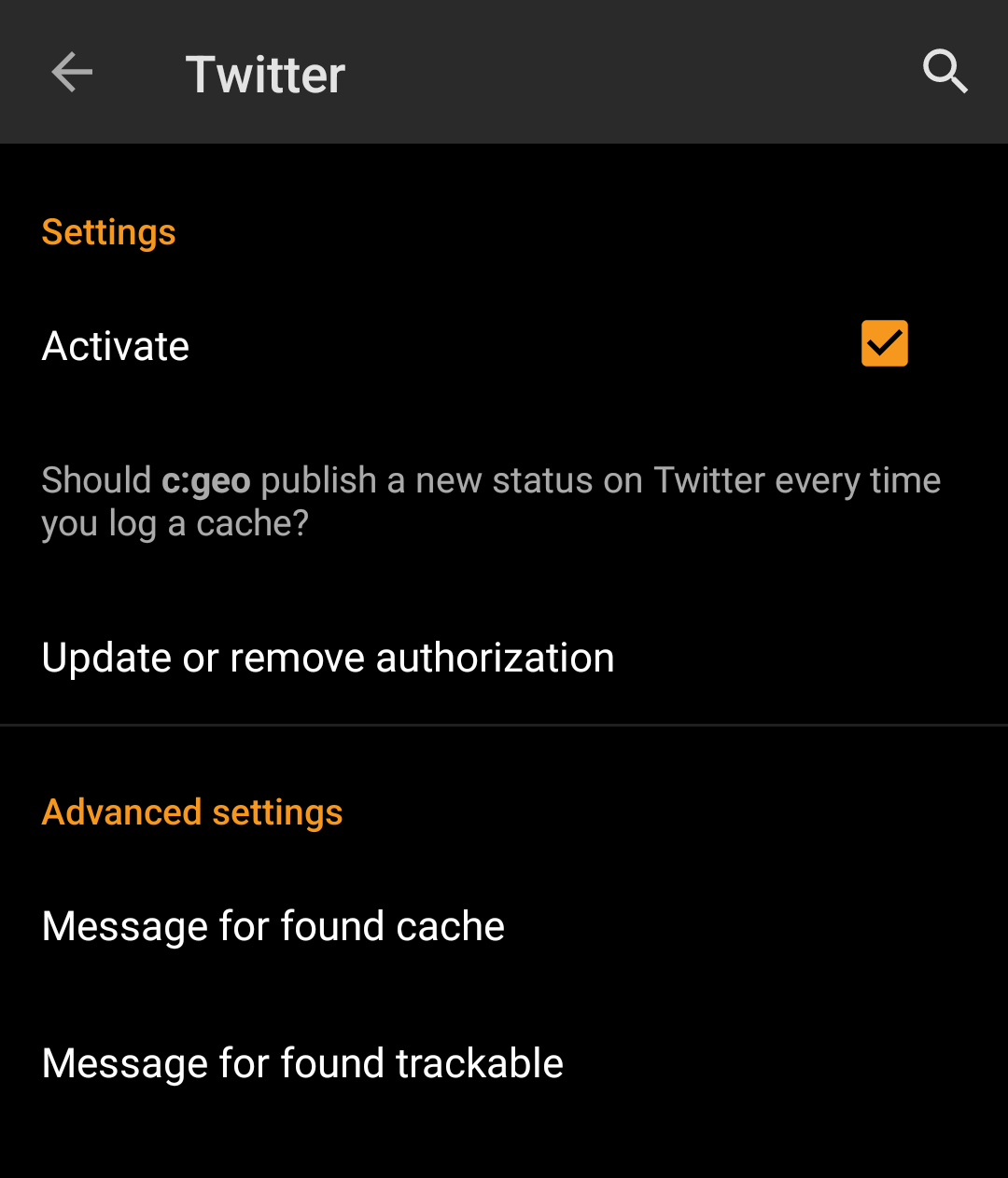
To authorize to Twitter activate the service and tap on Authorize c:geo.
Below the authorization buttons you can modify the templates which are used to post a message on Twitter. This template uses the same Placeholder templates as in your logging signature.

On the following page, tap on Start authorization to open the Twitter web page, where you have to enter your twitter username and password and afterwards agree to allow c:geo to post on Twitter on your behalf.
c:geo does only support Twitter as a social network. As the development team has limited resources and is focusing on new geocaching features we currently do not have plans to implement a Facebook connection.
However if you are Twitter user already and/or you are looking for a way to post your findings to Facebook, please note that there is a possibility to link Twitter to Facebook. Doing so all your tweets will also be posted on Facebook (including the c:geo tweets).
You can find more info on the Twitter support website.
Other settings
| Menu item | Description |
|---|---|
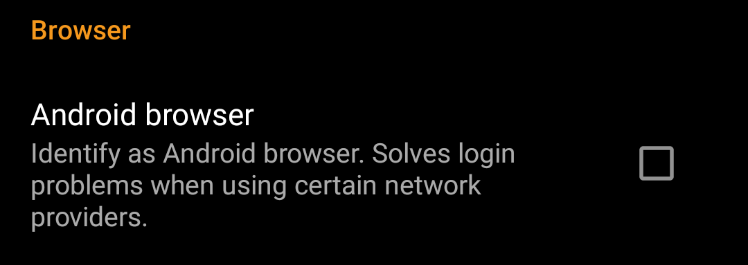
| Android browser | For compatibility reasons c:geo will normally use the identification of a normal PC web browser when accessing the services. As some mobile network providers do not allow using your mobile network connection on a PC, they might block traffic identified to target a PC web browser thus making c:geo unusable. In this case some services might not work or you cannot even get authorized. Enabling this setting will instead identify c:geo as a mobile Android browser to solve this problem. We recommend to only enable this option in case of problems. |
Appearance
In this menu you can configure some basic user interface settings of c:geo.

| Menu item | Description |
|---|---|
| Theme | You can choose to use c:geo with a light or dark theme or let the theme follow your system setting.(Default: System) |
| Colored light / dark theme | You can choose to use c:geo with a colored toolbar for cache-views.(Default: Activated) |
| Wallpaper | You can choose to use your device wallpaper also as background on the c:geo home screen (Default: Deactivated) |
| Show Address | When activated c:geo will use a reverse geocoding service to show the current location name instead of the location coordinates at the bottom of the main screen. (Default: Activated) |
| Plain Logs | Activating this setting will show all log entries without the custom colors for enhanced readability. (Default: Deactivated) |
| Select language | This setting allows you to manually set the used language for c:geo. This might be helpful in case you have problems with wrong translations in your language. A restart of c:geo is required after you modified this setting. (Default: Use default language of the device) |
| Use Imperial Units | Activating this option will make c:geo use imperial units (miles/feet) instead of metric units (meter/kilometer) on all relevant screens. (Default: Activated (for languages en-us), Deactivated (for all other languages) |
Cache Details
| Menu item | Description |
|---|---|
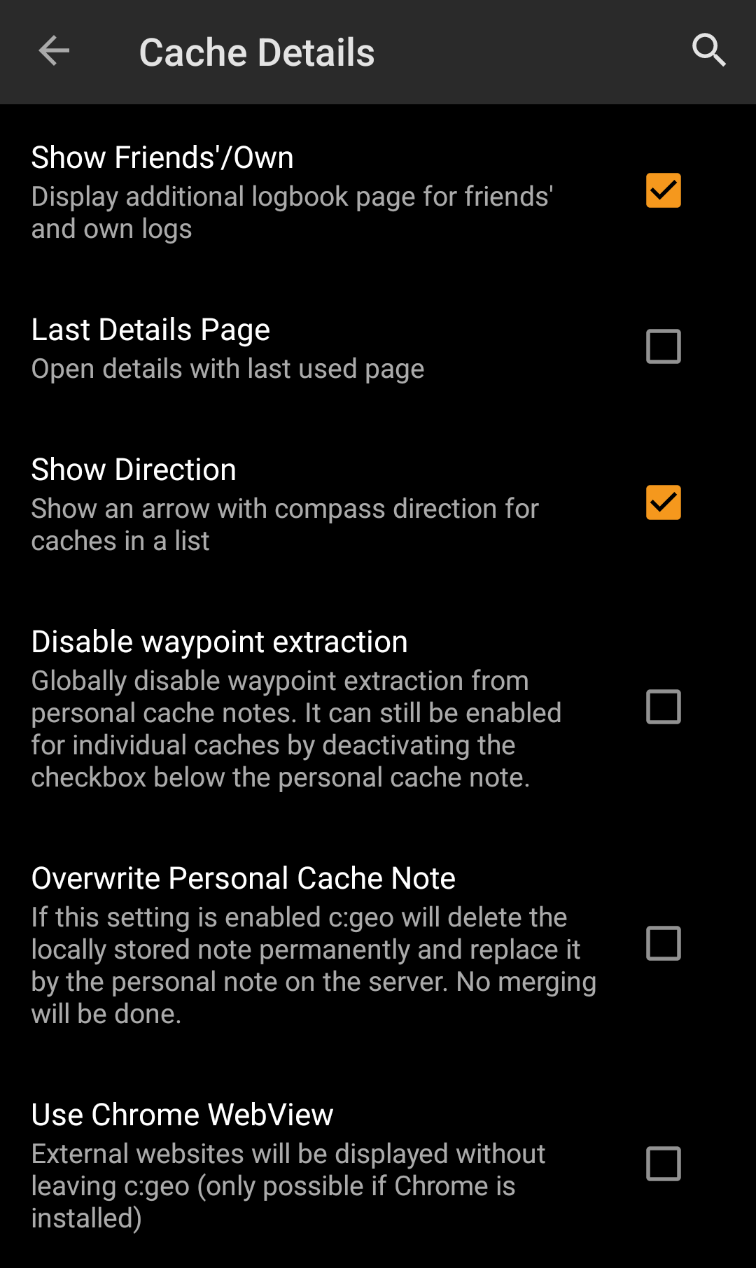
| Show Friends'/Own | Activating this option will show an additional logbook page in the details of each cache, which contains all your own logs of this cache as well as all the logs of your geocaching friends (based on the friend function of geocaching.com). (Default: Activated) |
| Last Details Page | When deactivated the cache details will always open with the page Details while activating this function will remember the last opened page and open any new caches on this page (e.g. waypoints). (Default: Deactivated) |
| Show Direction | This function will show small directional arrows in all cache lists, providing coarse information about the direction of a cache relative to your device. While this may help to figure out if a cache is e.g. in front or behind you, it is not designed to replace the other navigation methods in c:geo. (Default: Activated)  Please be aware, that for basic members of geocaching.com this function will in search results only show static direction images, but no moving arrows. Please be aware, that for basic members of geocaching.com this function will in search results only show static direction images, but no moving arrows. |
| Disable waypoint extraction | Enabling this setting will globally deactivate the feature of automatic waypoint generation for coordinates found in your personal caches notes. Alternatively you can disable the feature individually for a cache by deactivating the checkbox directly below the personal cache note. |
| Overwrite personal cache note | Activating this setting will cause all personal notes to be overwritten by the server content instead of being merged with the local content when refreshing caches. Activating this option might lead to data loss in your notes. Be careful. |
| Use Chrome Webview | External website will be shown in a chrome webview window directly in c:geo instead of opening your external device browser. This function requires Google Chrome to be installed on your device. |
| Encrypt hint | Activating this option will show the secret hint provided by the owner encoded, to not spoil the cache location. Deactivating this option will show the hint decoded. (Default: Activated) See Geocache Details - Hint section |
Map
Map Data
| Menu item | Description |
|---|---|
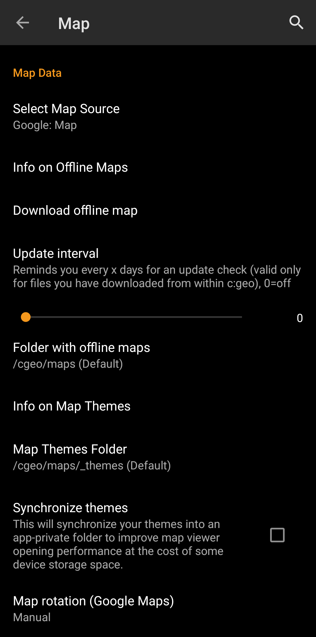
| Select Map Source | This allows you to define the map, which shall be used in all map functions of c:geo. The menu will contain all available online maps as well as the offline map files found in your offline map directory. You can change this setting also directly from the live map by tapping the map layer icon and selecting another map source. |
| Info on Offline Maps | This info item will provide you more detailed information about supported offline map formats and a link to the offline map tutorial in this user guide. |
| Download offline map | This will open the c:geo map downloader, where you can download new offline maps from various sources or update already installed maps. Details are described in the offline map tutorial of this user guide. |
| Directory with offline maps | Here you can configure the directory, which contains your Mapsforge offline map files. |
| Info on Map Themes | This info item will provide you more detailed information about supported offline map themes and some more hints for best practice. |
| Map Themes Directory | Here you can configure the directory, which contains your offline map themes. |
| Synchronize themes | In case you experience a slow performance when opening the map, you can use this option to synchronize your theme folder into an app private storage. This will increase the access speed but consume a bit more data storage. Please make sure your theme folder does not contain any unrelated (large amount of) data before enabling this feature! |
| Map rotation (Google Maps) | You can switch rotation of the map according to device heading off/on or enable manual rotation. This function is currently only available for Google Maps. |
Learn more about the c:geo offline maps by reading the chapter about Offline Caching!
Waypoints
| Menu item | Description |
|---|---|
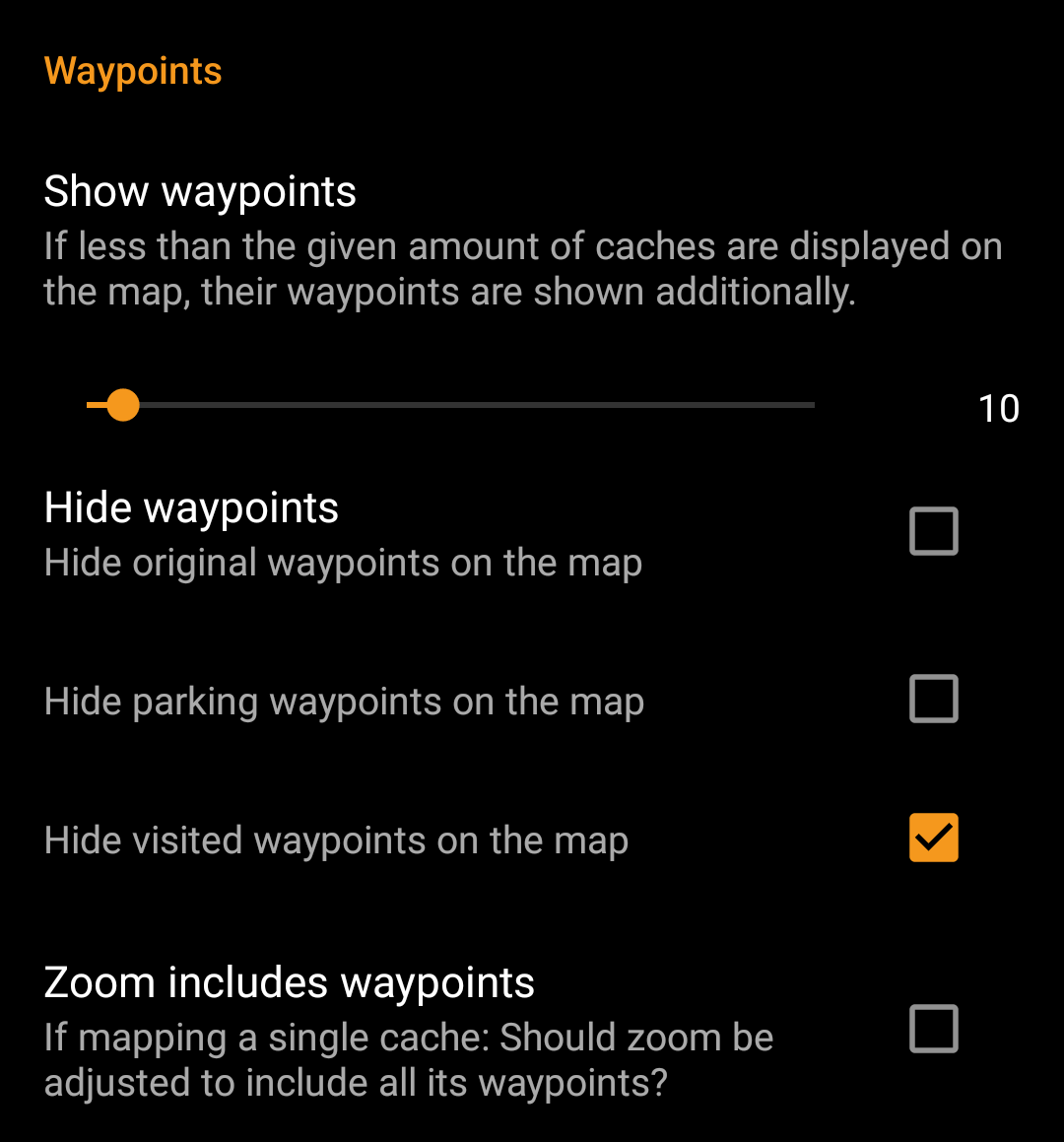
| Show Waypoints | Here you can set the limit for showing waypoints of (saved) caches on the map. If less than the selected amount of caches are displayed on the visible map area, their waypoints are shown additionally. You can either use the slider to set the value or tap on the number to set a new value. (Default: 10) |
| Hide Waypoints | These sub items allow to hide certain waypoint types on the map: 1. Hide original waypoints: If a cache has modified listing coordinates assigned and thus a waypoint automatically created, which contains the original listing coordinates, this function will hide this original coordinate waypoint. 2. Hide parking waypoints: Enabling this option will hide all waypoints of the type “Parking”. 3. Hide visited waypoints: Enabling this option will hide all waypoints, which are marked as visited by the user in c:geo. (Default: All off) |
| Zoom includes waypoints | If this setting is enabled the zoom level will include all waypoints of a cache, if you open a map for a single cache. (Default: Off) |
Map Content
| Menu item | Description |
|---|---|
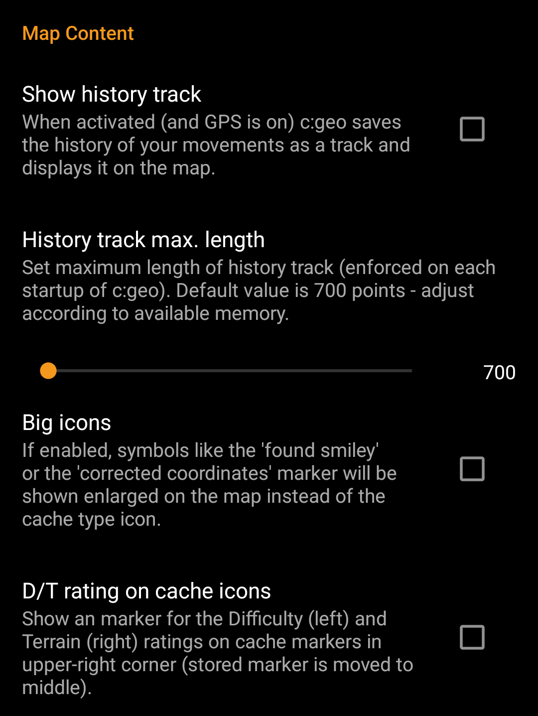
| Show history track | With this option you can activate a track showing your position history (your movement) on the map. (Default: Deactivated) Please be aware, that this will only be accurate as long as you use the map and have GPS enabled and will have gaps or jumps in case you switch your device to standby or deactivate GPS. If you would like a more reliable track recording you should rather use a specialized app. |
| History track max. length | Allows to raise the amount of track points available for the history track. Once the limit is reached the oldest recorded points will be removed if new points are recorded. Raising the limit however allocates more memory. (Default: 700 points) |
| Big icons for logged caches | If enabled the map will show big emoticons for logged caches instead of the cache type icon. A restart is required after changing this setting. (Default: Deactivated) |
| D/T rating on icons | Once activated all cache type icons will have a small overlay indicating the caches D/T-rating. You will find an explanation of those markers on the cache marker page of this user guide. |
Map behavior
| Menu item | Description |
|---|---|
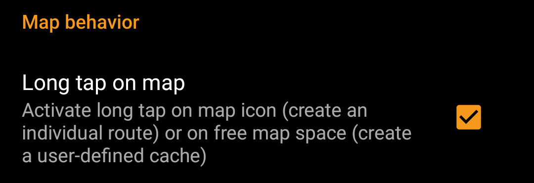
| Long tap on map | If enabled you can long tap on the map for two purposes: 1. Long tap on a cache or waypoint will add this cache/waypoint to your individual route. 2. Long tap on the map will trigger creation of a user defined cache. (Default: Deactivated) |
Proximity Notification
| Menu item | Description |
|---|---|
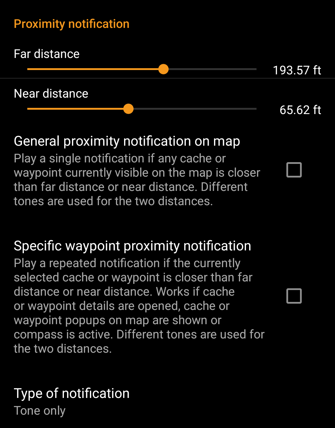
| Far distance | Defines the far distance for the proximity notification. You can either use the slider to set the value or tap on the number to set a new value. |
| Near distance | Defines the near distance for the proximity notification. You can either use the slider to set the value or tap on the number to set a new value. |
| General proximity notification on map | When enabled a single notification beep is issued if any cache or waypoint on the map comes closer than far or near distance. When reaching the far distance a single beep is issued, when reaching near distance a triple beep is issued. (Default: Deactivated) |
| Specific waypoint proximity notification | When enabled a repeated notification beep is issued if the currently selected cache or waypoint comes closer than far or near distance. This works if cache or waypoint details are opened, cache or waypoint popup on the map are shown or the compass is active. When reaching the far distance a single beep is issued, when reaching near distance a triple beep is issued. (Default: Deactivated) |
| Type of notification | With this menu item you can choose whether you would like to receive an audio notification, a text notification in your status bar or both. Hint: In case you are also using a smartwatch the text notification will allow some interaction with it, as the text notification should be shown on the smartwatch as well. (Default: Tone only) |
Depending on Android version and power saving settings on your device it might happen, that the proximity notification stops working if you switch off the display of your device. Please consult your device settings to solve this. We are also investigating how the behavior can be improved in general to allow background notification.
Map lines customization
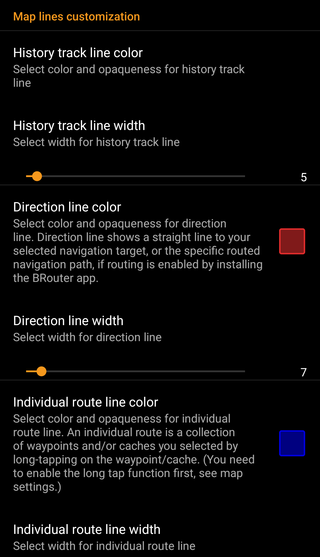

These menu items allow to customize the appearance of the different types of lines and circles shown on the map. You can change their color and opaqueness as well as the line width and the circle fill colors according to you personal preference.
Within each color selection you can reset color and opaqueness to their default values in case you misconfigured something. The default width is 10 pixels.
The following table briefly describes the different lines and circles and their usage:
| Menu item | Description |
|---|---|
| History track | If the history track is activated in map content settings a track of your movement will be drawn on the map. |
| Direction line | The direction line is a straight or specific routed navigation path (if the BRouter app is installed) from your current position towards a selected cache or waypoint (navigation target). |
| Individual route | An individual route is a collection of caches or waypoints you selected sequentially by long tapping them on the map. This function can be used to plan your caching trips by drawing a route from one cache/waypoint to another. The long tap function needs to be enabled in map behavior settings. |
| GPX track/route | The GPX track/route you imported from a GPX file in the live map menu. It can be used to visualize a given track you want to follow. |
| Circle | If activated in the map setting menu on the map c:geo will show circles with a distance of 1/10 mile (161 meters) around all physical waypoints (i.e. traditional caches, physical stages of a cache, mystery caches with corrected coordinates). This is the minimum distance placed caches need to have on geocaching.com and these circle might be helpful when you are planning to hide a new cache and are looking for a position. |
| Accuracy circles | This is a small circle drawn around your current position. It represents the uncertainty of your GPS position. |
Other map settings
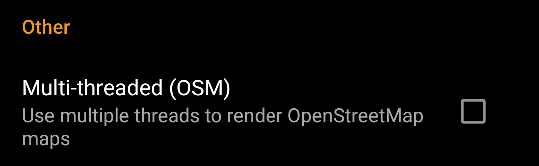
| Menu item | Description |
|---|---|
| Multi-threaded (OSM) | When activated the OSM map renderer uses multiple threads on your device processor to render the map. This will speed up map drawing but might in rare cases lead to drawing problems. It should be deactivated if you encounter problems in map display. (Default: Deactivated) |
Logging
Signature
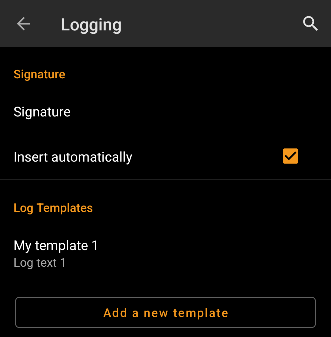
| Menu item | Description |
|---|---|
| Signature | Tapping this option will open a text window where you can define your custom signature template appended to each log you compose with c:geo. In the editor you can tap on Insert Template to get a list of possible placeholder templates you can use in your logs (see detailed table below). |
| Insert automatically | Activating this item will automatically insert the custom signature into your log text when you start logging a cache with c:geo. If this option is deactivated you can still insert your signature manually on demand by selecting + and Signature while composing your log. (Default: Deactivated) |
| Log template | In this section you can add/modify/remove custom templates for your log text. The templates defined here can then be inserted when logging a cache or trackable. |
Placeholder Templates
While creating your custom signature you can use several placeholder templates, which will be expanded later when the signature template is used:
| Placeholder name | Description | Example |
|---|---|---|
| [DATE] | The current date when composing the log. The date format will follow your phones global date format setting. | June 4, 2018 |
| [TIME] | The current time when composing the log. The date format will follow your phones global time format setting. | 14:50 |
| [DATETIME] | Combination of [DATE] and [TIME] as described above. | June 4, 2018 14:50 |
| [USER] | Your geocaching username for the respective geocaching platform where the cache you are logging belongs to. | My username |
| [NUMBER] | Your current find count for the respective geocaching platform, where the cache you are logging belongs to, incremented by 1, thus providing the find count for the cache you are logging. This template will also count for offline logs. | 4853 |
| [ONLINENUM] | Same as [NUMBER] but will not consider offline logged caches. | 4853 |
| [OWNER] | The geocaching username of the owner of the cache you are about to log | SuperOwner |
| [NAME] | Title of the cache you are about to log | My first hide |
| [DIFFICULTY] | The difficulty rating of the cache you are logging | D2,5 |
| [TERRAIN] | The terrain rating of the cache you are logging | T4,0 |
| [SIZE] | The size information of the cache you are logging | Large |
| [URL] | The URL of the cache page of the cache you are logging | http://coord.info/GC77 |
| [LOG] | This placeholder inserts the whole log text, which obviously makes no sense when using it in the logging template. It makes however sense to be used in the Twitter template. | This is my personal log text. TFTC! |
| [TYPE] | The cache type you are currently logging. | Traditional Cache |
Other logging options

| Menu item | Description |
|---|---|
| Visit TBs | Enabling this option will automatically set all Trackables in your inventory as Visited when logging a cache. (Default: Deactivated) |
| Offline Logging | Using this function will activate a One tap offline log function replacing the normal logging screen. It can be used to easily generate offline logs/field notes.The normal logging screen will still be available as a sub menu of the One tap offline log menu. (Default: Deactivated) |
| Show offline logs | An offline log counter (e.g. “+1”) will be shown next to your online find count on the home screen, if you have found logs, that are not submitted yet. |
Learn more about the c:geo offline functions by reading the chapter about Field Notes!
Offline Data
You can find more details regarding the offline usage of c:geo on the page Offline use!
Generic
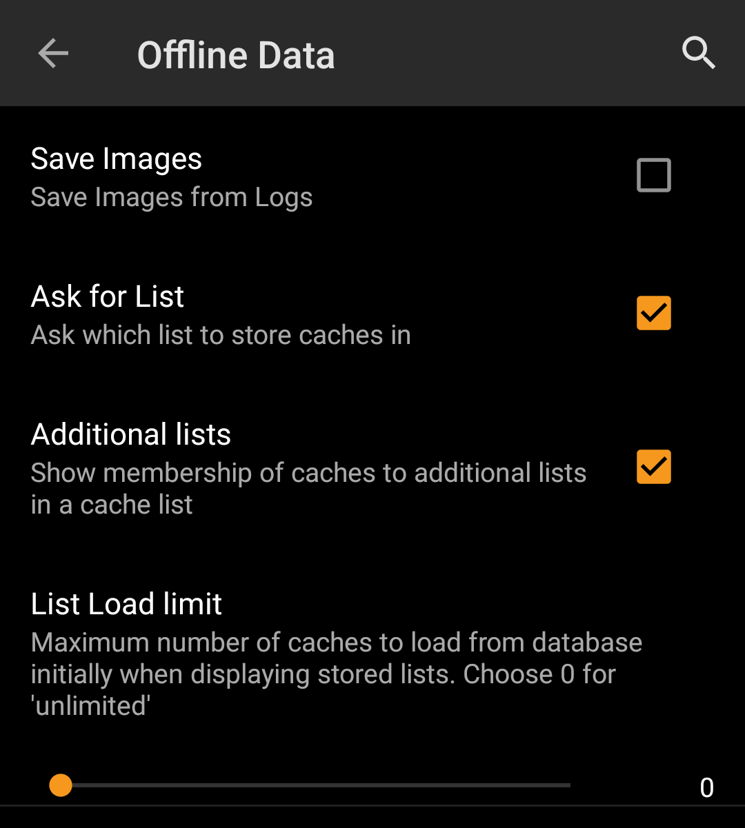
| Menu item | Description |
|---|---|
| Save images | If this option is activated c:geo will save all images contained in the caches logbooks onto your device for offline availability. You need to refresh already stored caches after activating this function to make their images available offline. If this option is deselected log images will be loaded on demand only (when opening them or accessing the caches image tab) but still be saved permanent afterwards until you delete the cache from your device. (Default: Deactivated) |
| Ask for List | When activated you will be asked in which list the cache shall be saved if you store a cache in c:geo. If it is deactivated all caches will be stored to the default list. (Default: Activated) |
| Additional lists | If this option is activated c:geo will show all additional lists, on which a certain cache is stored in c:geo, on your cache lists. (Default: Deactivated) |
| List load limit | You can use this function if you handle rather huge lists of offline stored caches. It will limit the amount of caches initially loaded from the c:geo internal database in order to increase performance. More caches can then be loaded by tapping on “Load more caches” when reaching the end of the list. (Default:0=No Limitation) |
GPX

| Menu item | Description |
|---|---|
| GPX Folder | Select the directory where GPX file exported from c:geo will be stored. (Default:/cgeo/gpx) |
Database and Geocache data
| Menu item | Description |
|---|---|
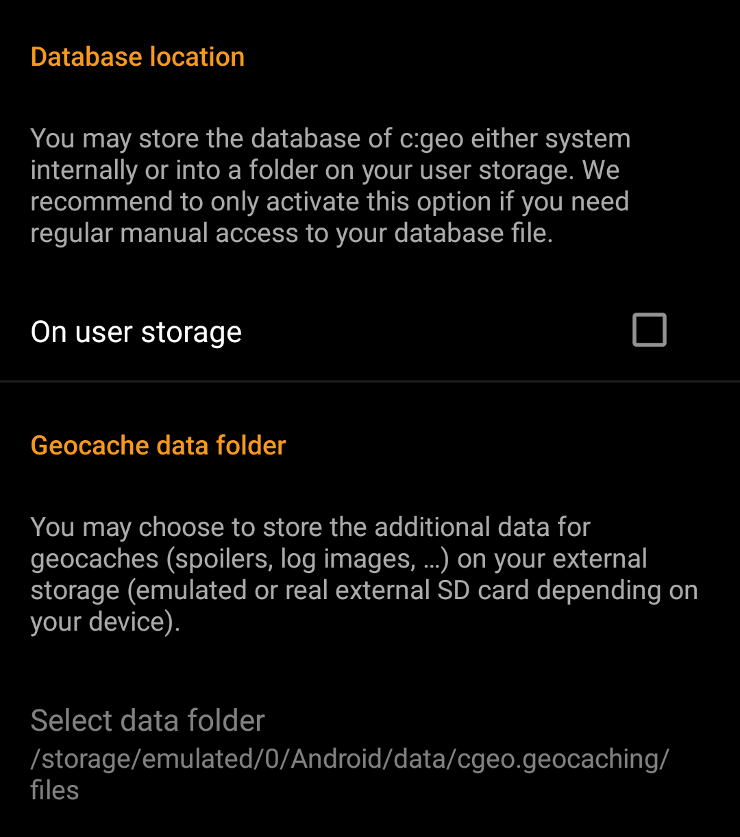
| Database location - On user storage | The geocache database mainly contains basically the list of your saved caches. You may store this database either system internally or in a directory on your user storage. Having it on the user storage may free some memory, but you may lose a bit of performance and c:geo will not work if the storage is not accessible or you remove the database file. As the database availability is critical for using c:geo and the typical size is only some megabyte, we decided to forbid moving it to the external SD card. If you enable the option On user storage the database will be moved to the folder /Android/data/cgeo.geocaching/files/databases (may vary depending on your device). On most up to date phones the system storage and the internal storage are in fact only different areas of the same physical storage. So this function will only make sense on some special phone types under special conditions. The SD card is never involved here. |
| Geocache Data Directory - Select Geocache Data Directory | The additional data can be much larger than the geocache database mentioned above as it contains the images of the cache description and (optionally) the images retrieved from logs and (optionally) static maps. By default this data is stored on the internal user storage in /Android/data/cgeo.geocaching/files/GeocacheData/. If your device supports using the external SD card this menu option will show you the available target directories as well as the current size of your geocache data and the available space on the target directories. The initial moving of the geocache data might take a long time depending on the amount of data to be moved. Please don’t interrupt the process and make sure your device is sufficiently charged. If you remove the external SD card or the SD card is full the additional geocache data will no longer be available and c:geo might no longer work as expected. |
Maintenance
| Menu item | Description |
|---|---|
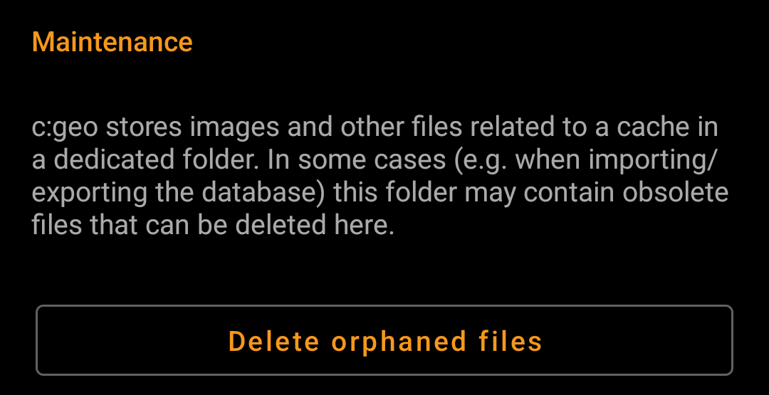
| Delete orphaned files | c:geo stores cache images, log images and other filed related to a cache in a separate directory (refer to Geocache Data Directory). In some cases (e.g. restoring a backup) this directory might contain outdated files of caches no longer stored on the device. These outdated data can be deleted by using this function. |
Navigation
Offline Routing
| Menu item | Description |
|---|---|
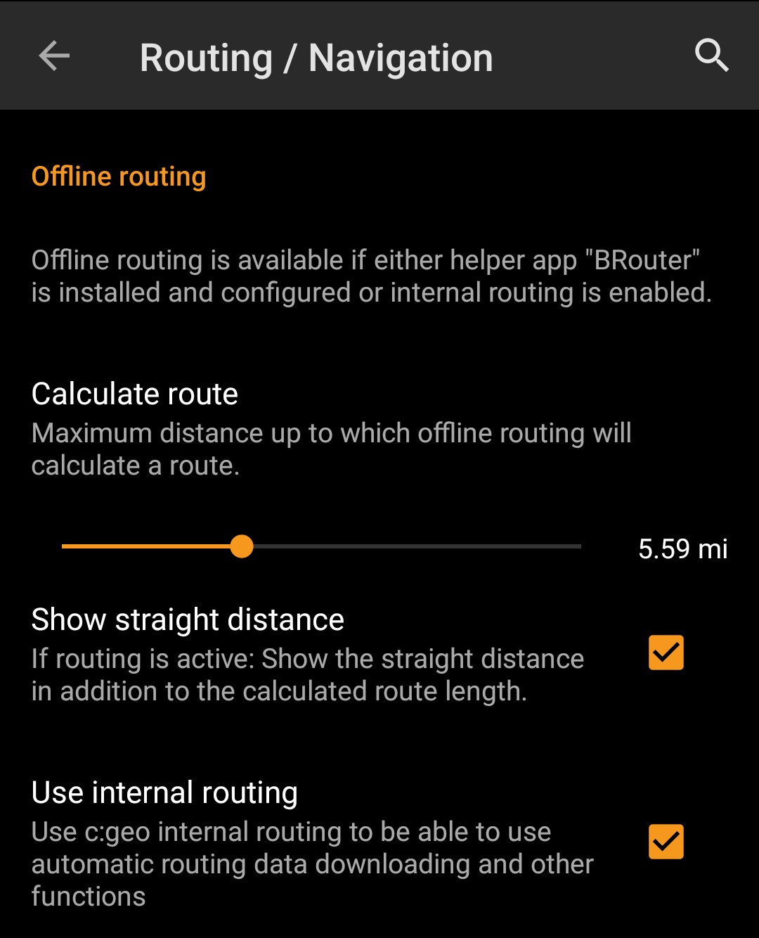
| Calculate route | With this setting you can select the maximum distance up to which a route is calculated and shown on the map between your position and the selected cache. You can either use the slider to set the value or tap on the number to set a new value. (Default: 10km) |
| Show straight distance | If the setting is active, the straight distance to the target will be shown additionally to the routed distance while routing is active. (Default: Deactivated) |
| Use internal routing | Activating this menu option will use the c:geo internal brouter enginge, instead of making use of the external helper app “Brouter”. c:geo will then also handle download and regular update of routing tiles. The external app is not needed anymore if this settings is activated.(Default: Deactivated) |
| Menu item | Description |
|---|---|
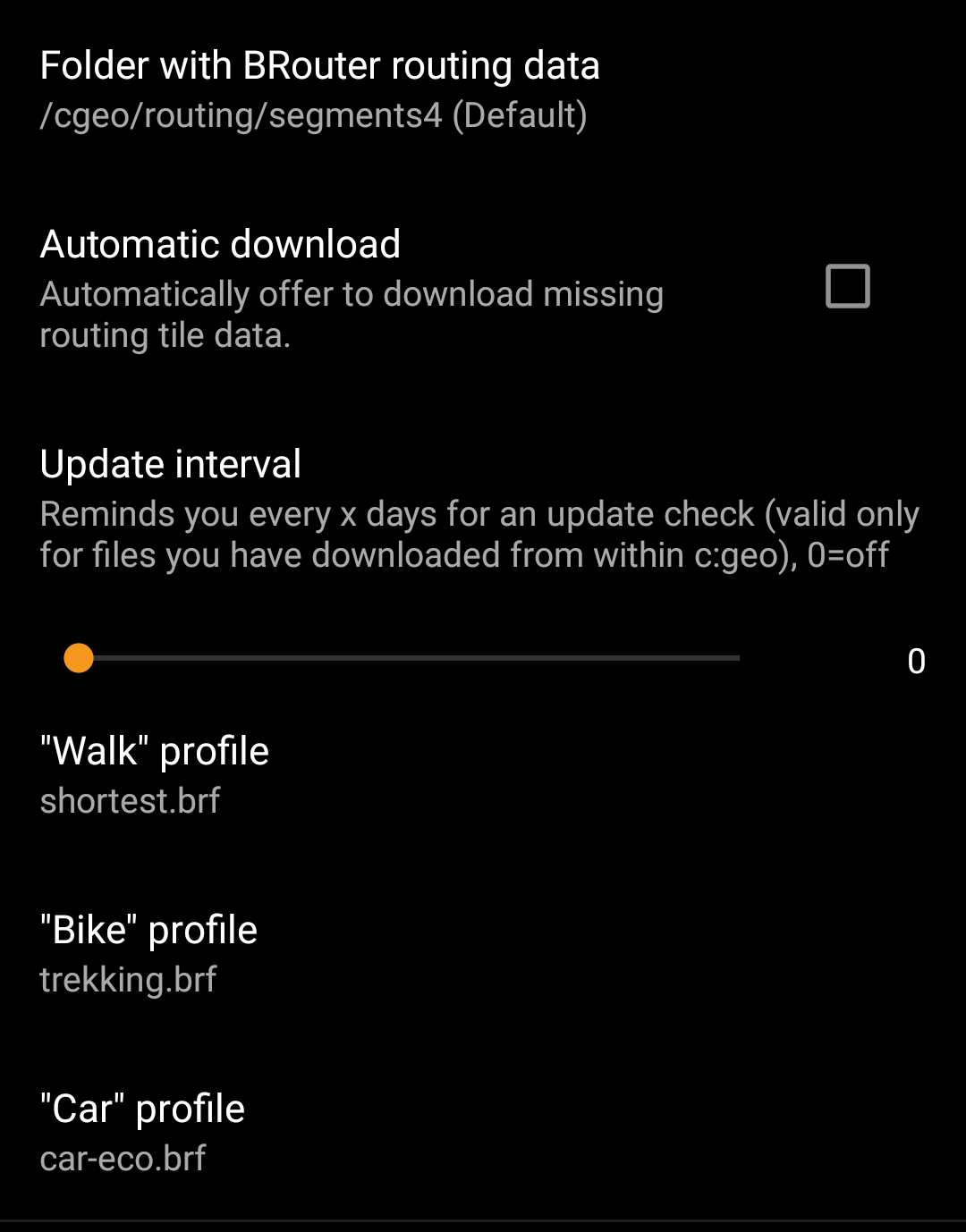
| Folder with BRouter routing data | If you use the internal routing engine, this defines the folder where routing tile data will be stored. You can either manually store/move the data into this folder or use the c:geo internal (automatic) downloader to download the needed routing tiles (Default: Subfolder routing/segments4 below the c:geo base folder) |
| Automatic download | Once activated c:geo will inform you, in case routing tile data for routing request (if you create an individual route or set a waypoint as target) is missing and offer to download it automatically into the folder defined above.(Default: Deactivated) |
| Update interval | If the automatic download is activated c:geo can also check periodically whether new routing tile data is available on the BRouter server and remind you to perform an update. You can set the update reminder interval here. You can set it to 0 to deactivate the update reminder (Default: 30) |
| “Walk” profile | You can define which of the available Brouter routing profiles shall be used for the navigation type “Walking” |
| “Bike” profile | You can define which of the available Brouter routing profiles shall be used for the navigation type “Bicycle” |
| “Car” profile | You can define which of the available Brouter routing profiles shall be used for the navigation type “Car” |
Navigation Tools

| Menu item | Description |
|---|---|
| Default navigation | You can select your default navigation tool here, which provides you easy and fast access to your preferred navigation method. The selected tool will be started with a short tap on the compass rose icon at the top of the cache details as well as the map popup window. (Default: Compass) |
| Secondary navigation | You can select your secondary preferred navigation tool here, which provides you easy and fast access to this navigation method. The selected tool will be started with a long tap on the compass rose icon at the top of the cache details as well as the map popup window. (Default: Map) |
| Navigation menu | This section provides the possibility to activate or deactivate some of the installed and available navigation methods detected by c:geo. You may use it to clean up the cache navigation menu by e.g. disabling navigation methods you are never using. (Default: All available are activated) |
Please refer to the supported navigation methods for detailed information about the navigation tools.
System
Base folder, Geolocation & Orientation
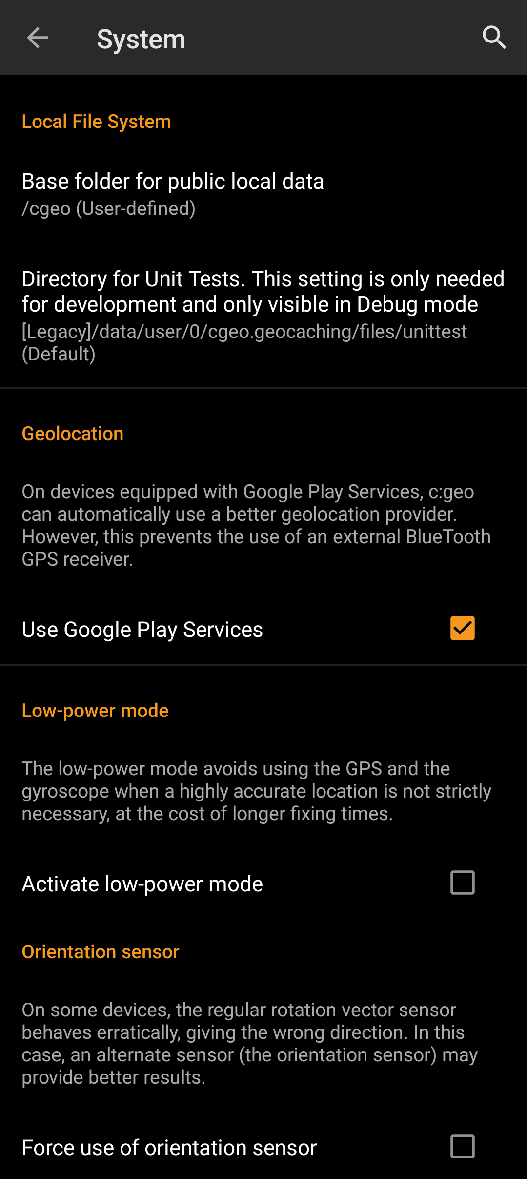
| Menu item | Description |
|---|---|
| Base folder for public local data | Here you can modify the base folder c:geo uses to store all its user accessible data (e.g. GPX-exports, offline logs, offline maps, etc.). We recommend to use /cgeo/ on an internal non-removable storage. |
| Use Google Play Services | On devices equipped with Google Play Services, c:geo can automatically use a better geo location provider to get better location results and reduce the battery consumption. If you want to use an external Bluetooth GPS receiver you have to disable this option! On some devices Google Play Services are available but not working reliable. If you experience localization problems or no GPS reception at all, try disabling this option. |
| Active low-power mode | The low power mode avoids using GPS and the gyroscope sensor in situations where a highly accurate location is not strictly necessary (e.g. on cache lists) at the cost of longer fixing times once high accuracy is needed again. It can help to enhance battery life in some situations. We however recommend to keep this option switched off to have the highest possible accuracy which is desirable for Geocaching in general.  |
| Force use of orientation sensor | On some devices the regular rotation vector sensor behaves erratically, giving the wrong direction when using the c:geo compass. In this case you can activate this option to instead use the orientation sensor, which may provide better results. We recommend to enable this option only in case of compass problems on your device. |
Debugging
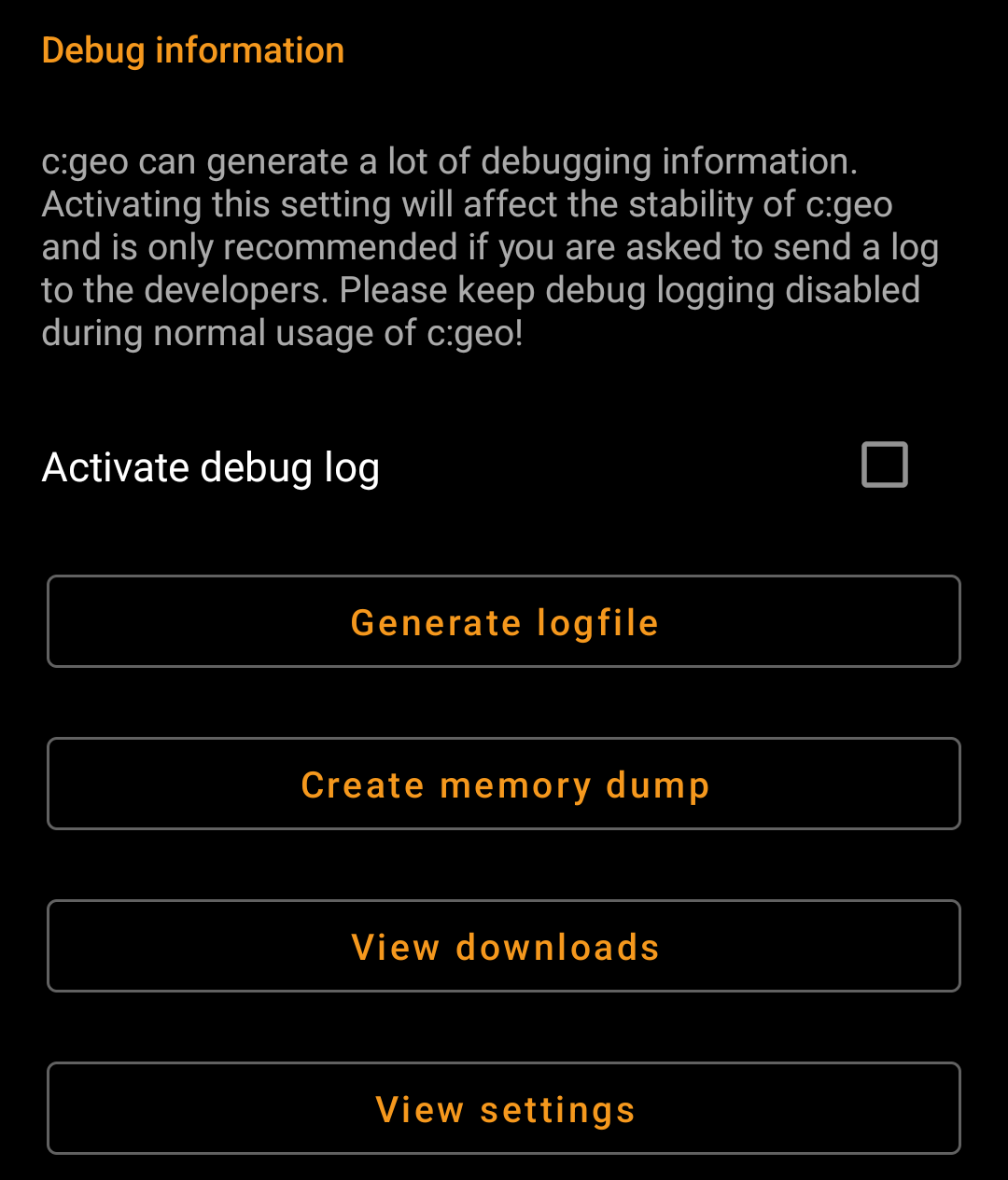
| Menu item | Description |
|---|---|
| Activate debug log | c:geo can generate a lot of debugging information needed for development purposes. Please use this feature only in case you are asked to send a log to the c:geo developers or you know what you are doing. Activating this setting will affect the stability of c:geo. Please keep debug logging disabled during normal usage of c:geo! |
| Generate logfile | Using this option will generate a system logfile to be send to the c:geo support in case of failures or crashes. Use as advised by c:geo support team (useful in combination with activation of debug log). |
| Create memory dump | This is a development function, which can help to debug special problems in the c:geo memory handling. Using this function is nothing helpful for you, but will only spam your internal storage with a rather huge dump file. So better not use it. |
| View downloads | Shows all pending background download processes. |
| View settings | This debug feature opens a view where all c:geo settings can be viewed and edited in a raw format. Changing anything here might result in unwanted behavior or c:geo no longer working. So only use this after explicit request by c:geo support! |
Backup / Restore
Create Backup
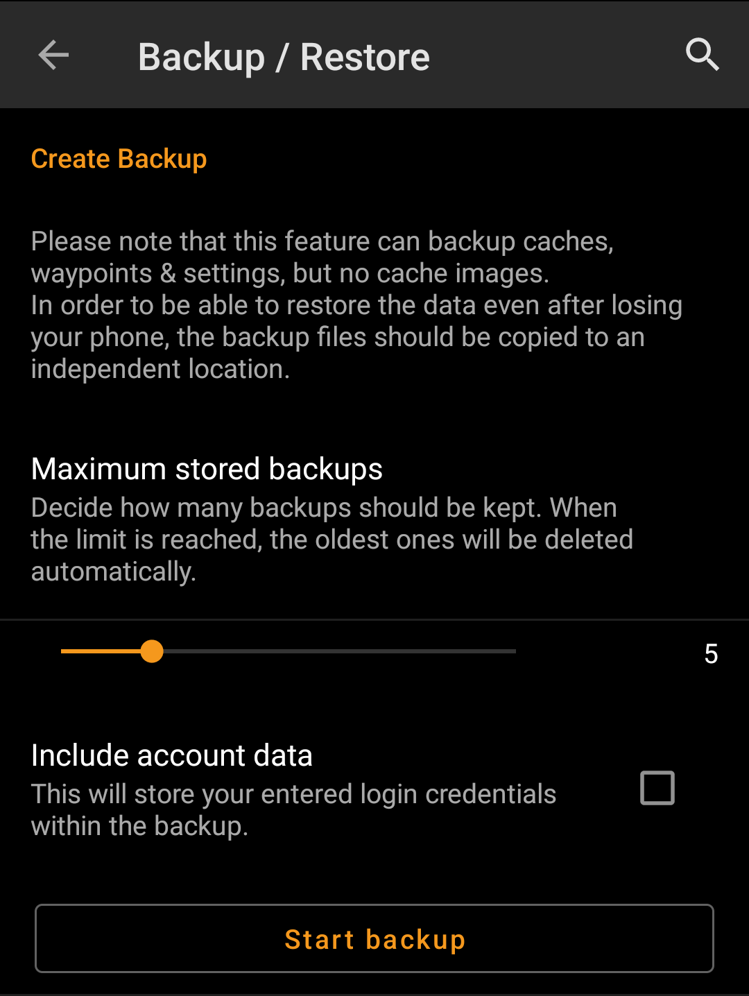
| Menu item | Description |
|---|---|
| Maximum stored backup | Using this slider you can select how many older backups are kept. When the limit is reached, the oldest ones will be deleted automatically. (Default: 5) |
| Include account data | If activated the created backups will also contain your login credentials. Please be aware, that backup files , thus also the login credentials contained, might be read by other applications on your device. |
| Start backup | Selecting this function will create a backup (cgeo.sqlite) containing all your saved caches and a backup of the program settings (cgeo-settings.xml) containing all settings of the app optionally (see above) also including your login credentials. The backup files will be stored below /cgeo/backup/ in your internal memory in a folder named by date and time of the backup. These backup files will be kept (even if you uninstall c:geo) until you manually delete them or the limit of maximum stored backups is reached (see above). |
Restore
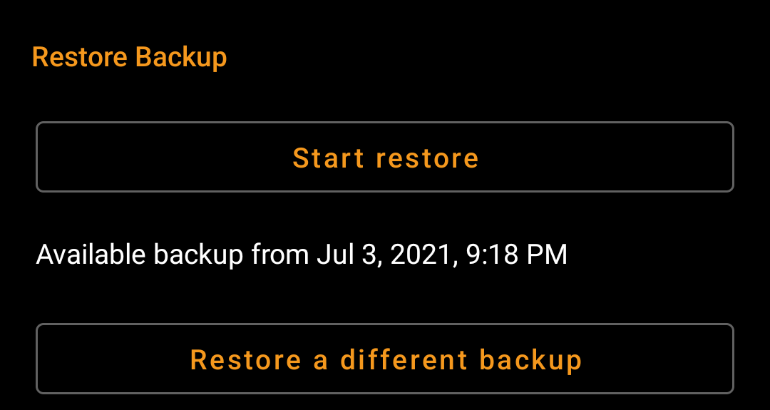
| Menu item | Description |
|---|---|
| Restore | This function will restore the newest available backup. The date/time of the newest backup available will be shown here. In a next step during the restore process you can choose, whether you want to restore the caches and/or the program settings. Restoring a backup will replace all caches and/or app settings by those contained in the backup. Be aware of that, when using this function. |
| Restore different backup | With this menu item you can select another available backup but the newest one to be selected for restoring. After tapping here a directory selector will be shown listing the existing backup directories named with date and time below /cgeo/backup/ as c:geo created them during your backup. Select the directory you want to restore from and press OK to continue with the restoration process.Optionally you can use the directory chooser to navigate to another location, where you placed your backup files and choose to restore from there. |
